The Mountain Route officially began near the Arkansas River Crossing area. Instead of crossing the river the Mountain Route took the trains along the river westward to Bents Fort. Most wagons traveled on the north side of the river.
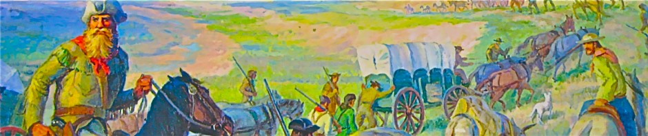
The Mountain Route, while usually providing more reliable access to rivers and springs, was not only some 100 miles longer but the rugged 3,000 foot elevation gain in just 32 miles, as it passed from Bent’s Fort Colorado over the Raton Mountains, exerted a physical toll upon men and draft animals alike. The passage over Raton Pass alone required a five day ordeal as the teams struggled up a steep 2,000 foot elevation gain in only twenty seven miles. Until that road was somewhat improved in 1863 by Dick Wooton and turned into a toll road, the previous trail was so narrow at times that it had to be propped-up by long poles supported by the mountainside below and was quite dangerous. Many wagons and draft animals as well as people were lost when one of those prop poles gave way.
Then, once up to the summit of the pass the wagons had to have their wheels chained tight to avoid their turning. This was done, as well as chaining some of the draft animals at the rear of the wagons, in order to control the wagon as it descended some 1,100 feet down into the town of Raton. Quite often the draft animals, which had survived the Raton Mountains passage, were so worn-out that they had to be exchanged at Fort Union for healthier animals. And a profitable business existed at Ft. Union repairing wagons and trading draft animals.

GIS NPS
1846 – 1847 (The US invasion route) 1848 – 1860 
GIS NPS
1861 – 1864 1865 – 1866
|
As I was trying to find more info regarding my great-grandfather, Robert Carter Lewis, Jr, I found your info on the Cimarron Trail. I was told by my father who knew my grandfather (from the maternal side of my family) that he “rode” the Cimarron Trail. I took it for granted that he must have driven cattle down this trail. I was surprised to find that it was a wagon train trail and trade route to Sante Fe, NM. I have a letter, dated December 15, 1908, from Ms. Belle Dieter who lived in Sante Fe, NM, to my grandfather who was working on her ranch in Tulerosa, NM. Has anyone ever heard of a ranch in Tularosa, NM owned by this lady? I loved your history of the trail. Thanks,